Big news kiddies! The RTA has ‘Unleashed’ their new journey planner – wojhati. I am not sure where they came up with the name, it probably means journey planner in Arabic, but I prefer to think its an acronym for Wookies Only Joke Heartily Aboard Transit, Ironically. Ironic, because Wookies are renowned for being stoic and hating transit - who knew they would joke once aboard? And what does this have to do with my journey?
I greatly enjoy the unleashings of the RTA, nothing is debuted or rolled out, its ‘unleashed’, like a virus on an unsuspecting public.

I have known about the journey planner for a while, I came across the page for it on the RTA website before I moved here, but unfortunately there were no links to the actual planner, nor any advice on when there might be such a link. The curious thing was the wording on the page made it sound like it was already up and running. There are many quirky things on the RTA’s website, it makes it kind of cute.
As soon as I saw the unleashing, I simply had to try out the journey planner. Would it give me the same advice as I had given myself? Would I be wowed by its amazing svengali-like ability to come up with bus route choices? I dropped everything I was doing (not much), and set about putting the program through its paces.
Good news! Wojhati is actually incredibly useful. In true RTA fashion, it has its funny little quirks, but I think it would stand up pretty well against the NYC MTA’s first attempt at a journey planner (though not quite as useful as say HopStop).
Once entering Wojhati-land, one enters the name of their origin and destination. Seeing as how Dubai lacks a street numbering system, this can be rather hit or miss. It all depends on how big the landmark you are starting or ending at is. Actually, it doesn’t even depend on that, I have no idea what it depends on since it was rather random. It recognized the Burjuman center, but somehow didn’t know where the Mall of the Emirates was. It knew where the Dubai mall was (despite not showing it on the map), but didn’t know where Jumeriah Beach Residence was (also not on the map curiously).
Luckily, you don’t have to only rely on typing in your origin and destination, you can also pick a point on a map! Very handy indeed for this crazy city we live in. As I mentioned above, the map is a bit random as well, none of downtown Burj Dubai exists, the marina isn’t built yet either. All of your older roads will be there, and anyone with a decent knowledge of Dubai should be able to locate their destination to within a few minutes walking – good enough for purpose.
Other options include; choosing your departure time and choosing transit modes (bus, abra, taxi and train (obviously not available yet)). There is an option to choose by fewest interchages, fastest journey, or least walking between interchanges. You can even choose your walking speed and maximum walking time between interchanges, very nice!
So how does it work? I would say pretty darn well. I checked out each of the bus routes that I already know from experience, and it came up with a very similar route and the suggested times were fairly accurate. It did have some funny choices at times, like taking 5 different buses between JBR and the burjuman (via Jebel Ali!), but for the most part it was very rational, I think it’s the bus routes themselves, or more accurately the roads on which the buses travel, that are whacky.
Here is a sample route from the Burjuman to the Mall of the Emirates (by the way, I never noticed previously, its initials spell MOE! New nickname for sure). It’s a route I was curious about because I had tried to make the journey previously, and was thwarted by a pernicious lack of information (I ended up taking a cab). As noted before, Wojhati hasn’t heard of the mall of the Emirates, despite it being labelled on the map, so I had to right-click on the map and echo-locate it myself (I find echolocation quite easy, I have been half dolphin since that unfortunate accident at Fermilab).
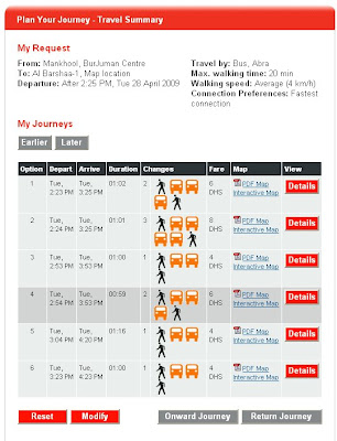 Wojhati's magical mystery buses
Once you identify your start and end locations, just click submit and Wojhati does its magic thingy and comes up with not one, but SIX, count ‘em, six different routes to MOE, unfortunately, no routes to Curly or Shepp.
As you can see, not all the routes are super handy, generally I try to avoid 4 interchanges in one bus journey, but it might be fun for the intrepid, or if you have a lot of dirham coins laying around that you don’t know what to do with. I am a smart and change-poor man, so I chose the two bus option.
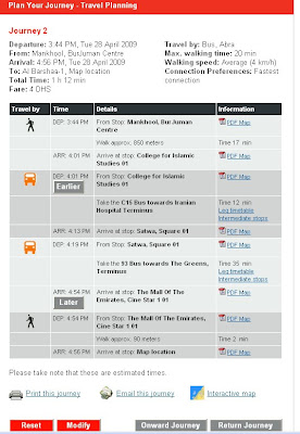
Details, details...
If you click on details, you get a page with all sorts of interesting journey info including interchange locations, journey leg times, interchange walking distances etc. You can also choose between an interactive (scaling) map of the route and a pdf of the route, which both include transfer location info.
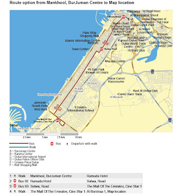
pdf version of route map
There are also some other helpful features: Departure Board, Timetable, Stop Timetable, My Timetable, and My Journey. They are all variations on a theme, basically giving you all of the possible times for different journeys or routes (where-as when you search Wojhati, it gives you a more narrow timetable). The Stop Timetable feature is quite handy for figuring out which buses leave from nearby. The My Journey feature requires you to log on and then you can set defaults for where you like to leave from and favourite journeys (I haven’t tried this out yet), which seems rather friendly.
All in all I have to say good job! To the RTA. This, more than anything before (except for buying all of those buses) should really help to get people to try out public transport. You definitely can’t beat the price, even with 5 interchanges its only 10 dirham to get from JBR to the Burjuman (even less if you are smart) – bargain mate!

No comments:
Post a Comment